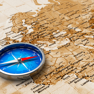
Orientation is the establishment of their coordinates on the map. Most often determined using a compass and a map. With sufficient knowledge - by stars, the sun, improvised means (hours, home -made compasses). Azimuth is a corner between the north, and a point on the map. The definition of azimuth will be needed in the skills of orientation on the ground. Especially this skill can be relevant in foot, bicycle drives in the mountains, forests, as well as in different extreme situations.
What is magnetic azimuth
This is a certain angle between the north found on the map, compass and the route point to which you need to come. Magnetic azimuth is always determined clockwise the compass. In order for the compass to give the correct indications, you need to move to the maximum distance from the magnetic objects that can give the wrong readings of the north, that is, it is initially incorrectly set the route.

How to determine the azimuth by card and compass
- To define Azimuth will need wabled Compass and map of the area.
- The azimuth covers all 360 degrees at the marks of the compass along the direction of the sentry Arrows.
- First you need to choose the right direction according to which movement will take place. On it calculated The angle of the azimuth.
- A person becomes a face in the direction of the landmark. Holds the card and compass in front of him.
- The compass arrow is on the brake. This brake should be released so that the magnetized arrow independently finds the North Pole. Not recommended Stand near iron structures, or have iron objects, while working with a compass. There is a high probability that the compass needle will give incorrect readings.
- The compass lies on the map, and its marks of the north coincide with the map marks.
- The location is established and the selected landmark is established.
- Further used Vizier. With its help, the desired direction is fixed on the compass, which should be followed.
- The angle between arrow, indicating to the north and point of the landmark will be called azimuth.
- A compass with a built -in ruler and a fixer of the selected direction will be very convenient and more correct.
- Determination of the route can fluctuate exactly.

How to determine the azimuth - movement by azimuth
- To do this, inspect the selected area passing along the route. Determine how more correctly it is possible to move so that not lose From sight of the landmarks. Perhaps you should do a little intelligence.
- For convenience, a low -fat dashed line is made marking route on the map.
- On a separate sheet of paper, the progress of movement is noted.
- When the movement has reached the next mark, you should choose the next landmark, and also make notes on a leaf of progress.
- Compass readings are lost from time to time. Do not forget update Compass settings reaching the point.

How to determine the azimuth - landmarks

A very important skill will be correctly indicating the goals on the ground or map. This skill is especially important if it is necessary to transmit data on communication (walkie -talkies) to determine your location relative to another person. A properly selected landmark can also help competitors find the necessary areas indicated according to a given plan.