Movement according to the specified route, regardless of the method, is always safer. The use of road atlas on a printed basis in the present days is no longer relevant, with a rare exception. Advanced information about the route between cities using the navigator or the Internet and online cards - an option suitable for travelers that contributes to the right and rapid movement.
1
To begin with, we carry a route through the Internet and online cards, which will not be difficult to find any work. Search engines "Yandex" and "Google", "Mail.Ru" have at their disposal cartographic services. Just enter through the search engine in the "Maps" section.
2
Open the card and click "Routes". We choose the option of movement - whether it is a car, a bus or foot. We establish the starting point of the path and the final, entering the settlements in the appropriate lines. The "Add Destination" command, the route laying will go through intermediate points, which can significantly reduce the time on the road, because the standard route is often held along the federal destination. If necessary, perform experiments with parameters.
3
Other services for laying simple automotive routes and counting kilometer simply crowded Internet. We make a search query "Get directed route" and choose from the presented sites interesting for you. The scheme is similar to Google map - the initial item and the final. Next, "pave" or "calculate" - on all sites in different ways.
4
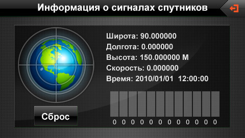
We will lay the route using the Navitel navigation system. In this case, it does not matter from which device (navigator, tablet or mobile phone) will be connected to GPS. We start and manufacture satellites (click on the icon with a satellite plate), for the accuracy of the location of the object of movement, let's say it is a car. Green plate - satellites found. Open area contributes to a good signal for satellites.
5
Returning to the "Magic" command to the Route command, then select the appropriate option of the initial and end point, for example, at either by adding travel points. We add the desired settlements (designated by flags) and begin to lay the route to the "go" command. Choose from two options - a short or fast route. If necessary, install intermediate settlements if you know their name.
The above options for laying the route are quite simple even for beginner travelers. For more experienced on the Internet, interesting, but complex programs for creating their own cards will be departed.